Cnoc na h-Eireachd: This Tump was located south of the A9 Inverness to Tore dual carriageway and north-west of the village of North Keswick. I left my car on the verge of the minor road beside Craigrory and walked a short distance back along the road to a stile. This took me into a field containing horses and through an open gate into an adjoining field which once crossed led to a second stile and beyond it a birch wood where sheep roamed.
Here the gradient increased as I passed an enclosed reservoir then followed sheep trails through the gorse. One of these trails led to Cnoc na h-Eireachd’s trig point.
I then retraced my route back to the car.
Gallow Hill: The starting point for this Tump was the Arpafeelie Chapel also located south of the A9 Inverness to Tore dual carriageway and west of my previous hill Cnoc na h-Eireachd. From there I followed a forest track round the east and south sides of Gallow Hill. At grid reference NH605/495 I came across a lesser used track which headed up onto the west side of Gallow Hill just west of the summit. It was then a short walk through some rough vegetation and well spaced trees to an area of heather which appeared to be the highest point.
The return was by the upward route.
Drumsmittal Hill: This Tump lay to the north of the A9 Inverness to Tore dual carriageway and east of the B9161 Munlochy Road. I parked at the end of the tarred road to the north of Drumsmittal Hill opposite The Stables. The plan was to walk through the wood and to the summit but the trees had recently been harvested with work still in progress.
I therefore walked west along a path to an area of mature trees, well enough spaced, and climbed through them although underfoot it was rough going with some fallen trees. On reaching the highest point I left the trees and entered the cleared area, crossing brash, to reach the now obvious summit area.
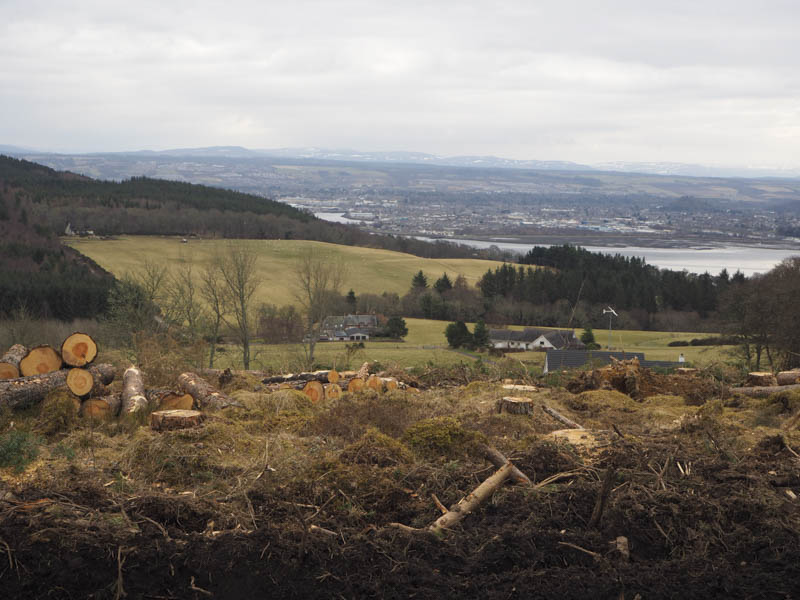
Rather than return to the mature trees I descended north along harvesting machinery tracks, which were relatively dry and made for a reasonably easy descent, except for the final few metres which were muddy. The path was reached a short distance west of The Stables.
Creag a’ Chaisteil and Taindore Hill: I parked on an area of hardcore beside a field of young fir trees at the highpoint on the minor road north of the A9 Inverness to Tore dual carriageway and south of Munlochy Bay. From there I crossed the road and passed through a couple of gates to reach a narrow path between new stock fences. Higher up I crossed a stile and climbed steeply through gorse onto a dun, being the summit of the Tump, Creag a’ Chaisteil.
I returned to the road by the upward route but continued east before leaving the road, crossing a stock fence, and entering a birch wood. I climbed through the trees and gorse bushes to the obvious summit of the Tump, Taindore Hill, before heading back to the start by the approach route.
Drumderfit Hill: The starting point for the ascent of this Tump was a small parking area to the west of Drumderfit Hill and to the south of the village of Munlochy. From there I walked east up a forest track to grid reference NH655/522. Here a rather wet and muddy track headed south through the trees. On reaching a felled area I climbed through some gorse bushes and brash then higher up headed back into the trees to the summit of Drumderfit Hill which was surrounded by gorse.
I walked north through the well spaced trees with areas of brash before descending to the wet and muddy track then returned to the start by the approach route.
- Total time – 3.25 hours.
- Total distance – 11.25 kilometres.
- Total height climbed – 350 metres.